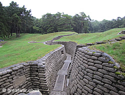
Towns & Villages on the French Flanders & Artois Battlefields
-
Armentières
50.687155
2.881730
Départment Nord, Nord-Pas-de-Calais Region
The town lies on the east bank of the River Lys and just south of the Belgian border. It is famous for its weaving, spinning and brewing industry dating from the end of the 19th and early 20th centuries. The town was awarded the British award of the Military Cross and the French Legion d'Honneur medal after the First World War.
After a very brief period of occupation by German forces the town was in Allied territory from 17th October 1914. Close to the Front Lines it became a British Army base and a place where troops spent relaxation time out of the trenches.
The town was evacuated by the British before the advance of German forces on 10th April 1918 during the German spring offensive and the Battle of the Lys. Armentières was recaptured by Allied forces on 2nd October 1918. Although the town had not been badly damaged from German artillery shelling, it was damaged by the German forces during their withdrawal in October 1918.
-
Arras
50.291027
2.777385
Départment Pas-de-Calais, Nord-Pas-de-Calais Region
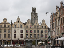
Arras is the capital of the Department of Pas-de-Calais. The town was occupied by the German Army from 29th to 30th September 1914. The Germans were driven out, however, and it remained in Allied territory for the rest of the war. It was very close to the Front Line battle area for most of the war.
-
Bailleul
50.739312
2.734523
Départment Nord, Nord-Pas-de-Calais Region
The ruins of Bailleul in 1918. GWPDA 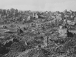
The town of Bailleul is situated to the north-west of Armentières in the Department of Nord. Archeological finds have dated the town to a site during the Gallo-Roman period in the 11th century. As with many towns in this region of Flanders it suffered damage from invading forces several times in its history.
During the First World War it was occupied for a short time in autumn 1914 by the German Army, but on 14th October 1914 it was captured by the British Expeditionary Force. It remained in British and French territory until 15th April 1918, when the German advance took the town during its spring offensive in the Battle of the Lys. A few months later the British 29th Division retook the ruined town on 30th August 1918.
During the time it was in British hands, from the end of 1914 to spring 1918, Bailleul was a front line town. Until it became the target of German artillery shells from July 1917 the town was busy with Allied troops passing through, resting out of the line, there were hospital facilities for treating the Allied wounded, and well-visited cafés in the market square.
-
Béthune
50.531160
2.638999
Départment Pas-de-Calais, Nord-Pas-de-Calais Region
The town was used as by British corps and divisional headquarters during the First World War, being a place with useful facilities and at a distance behind the fighting lines to avoid too much damage from enemy artillery bombardments. It was used for billeting troops, it was an important railhead for troop movement and supply lines. In 1914 and 1915 the Indian Corps was holding Béthune.
-
Bullecourt
50.192938
2.929417
Départment Pas-de-Calais, Nord-Pas-de-Calais Region
Mairie and French war memorial in the village of Bullecourt. 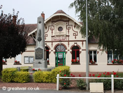
The village of Bullecourt lies to the east of Arras. The village was incorporated into the Hindeburg Line (known as the Siegfried Stellung by the German Army) by German forces. It was the scene of fighting in 1917 during the Battle of Arras, when the Australian 4th Division and the British 62nd Division attacked with tanks from 3rd May 1917. The village was completely destroyed by 1918.
-
Cambrai
50.175782
3.234658
Départment Nord, Nord-Pas-de-Calais Region
Two major First World War battles took place in the area of Cambrai: The 1917 Battle of Cambrai 20th November - 3rd December 1917 and the 1918 The Battle of Cambrai 8th-10th October 1918.
-
Festubert
50.543802
2.736079
Départment Pas-de-Calais, Nord-Pas-de-Calais Region
Festubert is in the area of the Battle of Festubert, an Allied offensive against the German line, which was fought from 15th to 27th May 1915.
-
Fromelles
50.605789
2.853994
Départment Nord, Nord-Pas-de-Calais Region
The church was built on the foundations of the former church, and inaugurated in 1927. 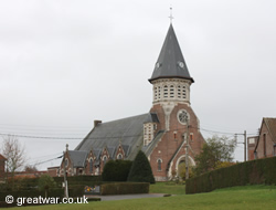
The village is located in the Department of Nord in the region of Nord-Pas-de Calais. It is situated about 8 miles south-west of the city of Lille. The countryside around Fromelles village is quiet, flat, fertile land used for agriculture. Fromelles is one of a number of small villages in an area characterized by the patchwork of small fields, copses and small-holdings.
The Imperial German Army occupied part of the village from 9th October 1914. The British Army fought at Fromelles in May 1915 during the Battle of Aubers Ridge.
On 19th and 20th July 1916 the British Army carried out an attack on the German line between Fleurbaix and Fromelles, known as the Battle of Fromelles. This was a joint attack by the British 61st Division and the Australian 5th Division. Originally intended as a diversion attack to divert German attention away from the British offensive in the Somme sector, this attack still went ahead 19 days after the launch of the Battle of the Somme. The casualties were heavy for the British and Australians. No ground was gained. The identifiable remains of many hundreds of British and Australian soldiers were never found and their remains still lie in the fields around this small village.
In 2008 a mass burial pit near to Fromelles village was identified and examined. The remains of British and Australian soldiers were exhumed and reburied in a new Commonwealth War Graves Commission cemetery. Some of the exhumed soldiers have since been identified as a result of DNA provided by surviving relatives.
-
Hazebrouck
50.722522
2.536436
Départment Nord, Nord-Pas-de-Calais Region
Hazebrouck Town Hall. (1) 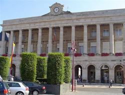
The town was an important railway junction from the late 1800s and for this reason was a strategic town for the Allied forces to operate from as a base. It became a key town in the Allied Lines of Communication for supply, equipment and troop movement. During the First World War the Saint-Francis of Assisi College was used as a British field hospital by Casualty Clearing Station Number 12.
-
La Bassée
50.532013
2.804067
Départment Nord, Nord-Pas-de-Calais Region
Barges on the canal at La Bassée. 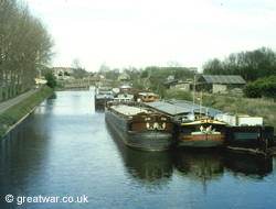
From 9th October 1914 the area around La Bassée was witness to fighting between the German 6th Army and the British Cavalry, the Indian Lahore Division, and units of the French 10th Army. This battle, the Battle of La Bassée, was one of the battles in the Race to the Sea of autumn 1914, where the German and Allied Armies moved in a north-westerly direction through France into Belgium in their attempt to outflank one-another.
This town was in German occupied territory for most of the war. Barges on the canal were used by the German Army to billet troops in.
-
Lille
50.631867
3.060226
Départment Nord, Nord-Pas-de-Calais Region
German troops parading in Lille, occupied by Imperial German forces from October 1914 to October 1918.GWPDA 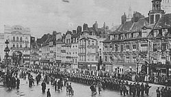
The city of Lille is also known by its Dutch name of Rijsel. It is the capital of the region of Nord-Pas-de-Calais. Lille fell to German forces on 12th October 1914. Much of the city had been destroyed by German artillery shelling in the early weeks of the war.
Lille was used as a German Army headquarters and its military fortifications, modified in the 1670s by Sébastian le Prestre de Vauban, were useful as a purpose-built, fortified military garrison behind the Front Line for German forces. The city was recaptured by British forces on 17th October 1918.
Today Lille is a commercial centre in the region offering a variety of tourist attractions and accommodation for visitors. It has an airport and a Eurostar rail service to and from the United Kingdom.
-
Loos-en-Gohelle
50.457660
2.792354
Départment Pas-de-Calais, Nord-Pas-de-Calais Region
Mairie in the centre of Loos-en-Gohelle. 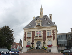
In the late 1890s the discovery of coal in the area changed this village from a farming community into an industrial mining town with pit heads and slag heaps. The Germans occupied the town until British forces took it on the first day of the Battle of Loos on 25th September 1915.
By the end of the war there was nothing recognizable of the pre-war bustling community; the town and surrounding area were pounded into a moonscape.
-
Monchy-le-Preux
50.270633
2.893862
Départment Pas-de-Calais, Nord-Pas-de-Calais Region
British 37th Division monument on the high ground in the centre of Monchy-le-Preux. From here there is a view of Arras through the trees to the left of the memorial. 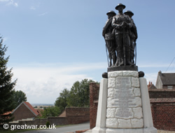
The village is located on high ground about 10 miles south-east of Arras. This was the location from where the German artillery forces bombarded Arras with shells during the war. The village was badly damaged in the Battles of Arras during the spring 1917. It was captured by the British Army in April 1917.
From the high ground in the centre of the village there are views to the west towards Arras.
-
St. Omer
50.750044
2.251698
Départment Pas-de-Calais, Nord-Pas-de-Calais Region
The town was behind the British Front Line during the war. It was used as a base for Allied flying services. The Royal Flying Corps set up a headquarters at the airfield on 8th October 1914 and from that time it grew into an important base for air operations throughout the war.
Related Topic
See our page introducing the places to visit on the French Flanders & Artois battlefields:
Visiting the French Flanders & Artois Battlefields
Acknowledgements
(GWPDA) Photographs with grateful thanks to the Great War Primary Document Archive: Photos of the Great War.
(1) Hazebrouck Town Hall photograph: Source Wikimedia Commons, used under the terms of the GNU Free Documentation License
